
From the moment the first towns and cities arose, the struggle for land, resources and power has turned to violence. Almost from the start, maps have been an inseparable part of warfare.
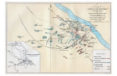
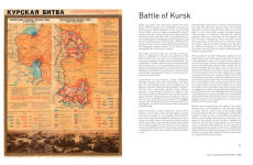
Each map in this beautifully designed volume plays a crucial role. While countless campaign strategies have relied on detailed and accurate mapping, entire wars have been fought over the maps themselves, with hopes of redrawing boundaries and redefining nations. This book expertly curates more than 70 historical maps which tell the fascinating story of war: from ancient and medieval warfare to modern day conflicts and beyond.
Featuring maps of historic battles such as:
• Battle of Marathon, 490 BC
• Battle of Hastings, 1066
• Battle of Crecy, 1346
• Battle of Lützen (Thirty Years’ War), 1632
• Battle of Saratoga, 1777
• Battle of Austerlitz, 1805
• Battle of Balaklava (Crimean War), 1854
• Siege of Vicksburg, 1863
• Battle of Isandhlwana (Anglo-Zulu War), 1879
• Battle of Spion Kop (Anglo-Boer War), 1900
• Gallipoli campaign, 1915
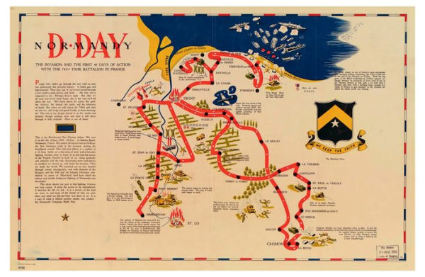
• D-Day, 1944
• Operation Desert Storm, 1993
From the moment the first towns and cities arose, the struggle for land, resources and power has turned to violence. Almost from the start, maps have been an inseparable part of warfare.
Each map in this beautifully designed volume plays a crucial role. While countless campaign strategies have relied on detailed and accurate mapping, entire wars have been fought over the maps themselves, with hopes of redrawing boundaries and redefining nations. This book expertly curates more than 70 historical maps which tell the fascinating story of war: from ancient and medieval warfare to modern day conflicts and beyond.
Featuring maps of historic battles such as:
• Battle of Marathon, 490 BC
• Battle of Hastings, 1066
• Battle of Crecy, 1346
• Battle of Lützen (Thirty Years’ War), 1632
• Battle of Saratoga, 1777
• Battle of Austerlitz, 1805
• Battle of Balaklava (Crimean War), 1854
• Siege of Vicksburg, 1863
• Battle of Isandhlwana (Anglo-Zulu War), 1879
• Battle of Spion Kop (Anglo-Boer War), 1900
• Gallipoli campaign, 1915
• D-Day, 1944
• Operation Desert Storm, 1993

History of War in Maps
256


History of War in Maps
256Hardcover

Product Details
| ISBN-13: | 9780008506490 |
|---|---|
| Publisher: | HarperCollins UK |
| Publication date: | 02/01/2023 |
| Pages: | 256 |
| Product dimensions: | 8.39(w) x 10.87(h) x 1.00(d) |