Read an Excerpt
Prospects for Resilience
Insights from New York City's Jamaica Bay
By Eric W. Sanderson, William D. Solecki, John R. Waldman, Adam S. Parris ISLAND PRESS
Copyright © 2016 Eric W. Sanderson, William D. Solecki, John R. Waldman, and Adam S. Parris
All rights reserved.
ISBN: 978-1-61091-734-6
CHAPTER 1
Why Prospects for Resilience for Jamaica Bay?
William D. Solecki, Eric W. Sanderson, John R. Waldman, and Adam S. Parris
New York City woke up to issues of resilience on October 29, 2012. One might have thought that the first twelve years of the twenty-first century would have already made the point. Terrorism in 2001, major street protests in New York City in 2003 and 2011, an electricity blackout in 2003, major heat waves in 2006 and 2008, financial collapse and recession in 2009–2010, and other storms such as Tropical Storm Tammy in 2005 and Hurricane Irene in 2011, all significantly disturbed the everyday life of the city and in some cases put significant pressure on the established order. They were shocks that destroyed physical, social, and economic structures, and afterward required a process of recovery through which structures were rebuilt. The capacity of a system to recover from shocks such as these, and adapt to changing drivers and disturbances, is resilience.
What made October 29, 2012, different was the scope of the damage. That day and night Hurricane Sandy plowed into the coast of New Jersey, affecting the lives directly or indirectly of every one of the 22 million people across the New York City metropolitan region (figure 1-1). Sandy had risen as a tropical storm seven days earlier in the Caribbean, toward the end of the usual Atlantic Ocean hurricane season. The storm tracked north, gaining strength as it made landfall with hurricane-strength winds on Jamaica and then Cuba.
As the storm left land over Cuba, it seemed that it might become disorganized and dissipate, but another weather system moving west to east across North America added energy to Sandy and caused the eye of the storm to pivot toward the north-northeast, aiming at the coasts of New Jersey and New York. By the morning of October 29, Sandy was a Category 2 hurricane and had grown to a tremendous width of 1,150 miles. Although its force had diminished to tropical storm strength (approximately 75-mile-per-hour winds) when the center of Sandy landed at Brigantine, New Jersey, to the south of New York City, its effects were not only atmospheric but also oceanic. Winds drove massive waves against the shore in advance of the storm itself. When Sandy hit the coast, waves were riding on and over the top of both a storm surge and a high tide, itself amplified by the full moon and the proximity of the equinox, when high tides are at their most extreme. Storm surges that night averaged nine feet above mean sea level and in some places exceeded fourteen feet. Rain fell and fell, eventually accumulating over ten inches in some areas. Along the coasts, the deluge worsened flooding on streets already inundated by the sea.
Overnight, Sandy slowly moved inland and began to weaken, cut off from its energy supply in the warm oceanic waters. The storm had resulted in more than 150 deaths and many more injuries (Hurricane Sandy Rebuilding Task Force, 2013). Houses along the shore were blown over or lifted off their foundation, filled with sand, and soaked. In New Jersey, New York, and Connecticut, approximately 380,000 buildings were damaged or destroyed. Tens of thousands of people were displaced. Transportation, energy, food, and fuel supplies were all disrupted and would continue so for days afterward. The subways shut down because all subway tunnels were flooded by seawater, making it difficult to get to work, so many people tried to drive, causing massive traffic jams. There was a run on gasoline as rumors spread that there was not enough of it to go around given the damage to shoreline gasoline distribution facilities. New York City's mayor, Michael Bloomberg, decided to call off the New York City Marathon, leaving thousands of tourists wandering around the city in running apparel, gaping at the restaurants and stores closed for lack of power and supply. Total economic damages in the metropolitan region have been estimated at more than $60 billion, including both direct and indirect losses, making Sandy the second costliest hurricane in U.S. history (Hurricane Sandy Rebuilding Task Force, 2013) after Hurricane Katrina in 2005 (figure 1-2).
No one wants to relive the pain and anguish of Hurricane Sandy, and indeed as we write four years later, the hurricane still swirls in the consciousness of New Yorkers and their government leaders. Many parts of the city have rebuilt, some just like they were before, some in ways reflecting the experience of Sandy, and yet other places remain damaged and forlorn. With crisis comes opportunity, and one of the opportunities that Hurricane Sandy brutally unveiled was the chance to seriously think about prospects for resilience. What does it take to make a coastal city like New York resilient? How do we understand disturbances in the context of history and nature, and how do we enhance the ability of people and nature to recover after them?
These are questions that not only New York City is facing but increasingly so are other cities in the United States, such as New Orleans and Miami, and other cities around the globe, such as Amsterdam, Dhaka, and Bangkok. It is in these places that future sea level rise is forcing consideration of a series of questions about the risks and hazards of long-term use and habitation of the coastal zone.
Why Resilience of Jamaica Bay?
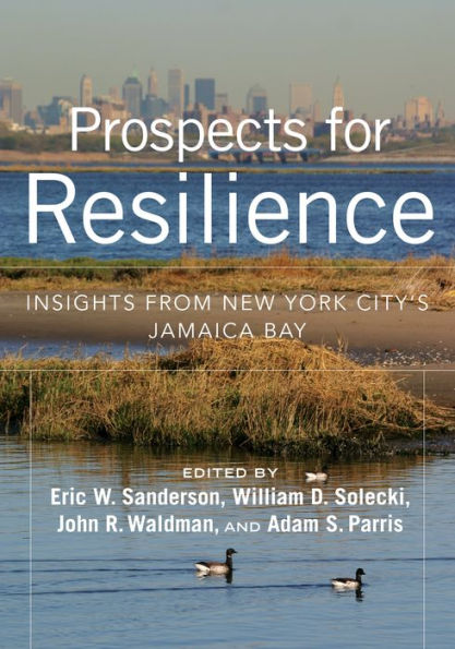
This book focuses on the prospects for resilience for an urban watershed where the issues come into unusual focus and clarity: Jamaica Bay (figure 1-3; see color plates). Despite the name, Jamaica Bay is not in the Caribbean, but rather it is a large coastal lagoon on the southeast side of New York City, in the boroughs of Queens and Brooklyn with a small portion in Nassau County, a neighboring New York State county. As we will learn in the second part of the book, the Jamaica Bay watershed is at the meeting place between land and sea, serves as a critical wildlife refuge, especially for migratory birds, is home to over two and a half million New Yorkers and a sight familiar to the more than 50 million air passengers peering out of windows at the twinkling green and blue waters below as their planes lift out of or land at John F. Kennedy International Airport.
Like many other urban estuaries, the boundaries of the bay and its environs before extensive urbanization (for Jamaica Bay, starting in the late nineteenth century) were dynamic and changeable. Shifts occurred gradually, as with century-long changes in sea level, or at punctuated moments, with disturbance events, such as the hurricanes or nor'easter storms. Although human impacts on the local ecology and landscape have long been felt, it was during the twentieth century that the edges of the bay became more hard, angular, and policy-constrained. Land reclamation, waste dumping, and large-scale infrastructure development made the bay's boundaries and jurisdictions more relevant in the everyday experience of area residents.
Jamaica Bay is a useful lens for thinking about resilience for three distinct and complementary reasons, explored in the following three sections, that we believe are also salient for other urban estuaries and watersheds. First, Jamaica Bay is a human-dominated, significantly degraded, coastal, social-ecological system (SES). The concept of SES is discussed further below, but refers to the interlinkages between the physical, ecological, and social systems of Jamaica Bay. As an interconnected SES, the people of Jamaica Bay struggle with a wide array of different disturbances operating over different time scales, from coastal storms to a complicated land use history to uneven and uncertain economic trends. Second, in large part because of its history and level of urban development, governance of Jamaica Bay has become complicated, multilayered, and in some cases, almost dys-functional. Recently, forward-looking leaders in public and private sectors established an institute for science and resilience at Jamaica Bay as part of an agreement to co-manage the natural areas as a single ecological system. This boundary organization is critical to prospects for resilience going forward (as discussed below and in chapter 12). Third, as you will read throughout the book, relevant sciences have matured to the point where an integrated understanding of Jamaica Bay is beginning to emerge, setting the stage where we might begin to see and plan for long-term resilience.
Although the exact circumstances are particular to Jamaica Bay, they are not unique. Many parts of many urban regions throughout the United States and the world suffer from damaged and failing physical systems, ecosystems, and social systems, with the potential of disturbance from both natural and anthropogenic causes. Leaders in government and civil society are looking for models to improve all aspects of SESs. In Jamaica Bay we don't have all the answers, but we are trying. We see this book as the foundation stone of our efforts over the coming decades: to lay out what we know, to take stock of what we don't, and to summarize and synthesize the issue of resilience for ourselves and for others working on similar issues elsewhere.
Jamaica Bay: A Local Social-Ecological System with a Global Problem
Throughout the book we will refer to the concept of a social-ecological system. We believe that this concept is fundamental to resilience, not only in Jamaica Bay, but in any landscape where people and nature are in strong interaction (Folke et al., 2007). This concept is built upon observation that there are no so-called natural systems without people (at least in modern times and especially in urban areas), and, conversely, there are no social systems without nature (Berkes and Folke, 1998). From this perspective, social and ecological systems are truly interdependent and constantly coevolving and are not separate systems existing in parallel needing to be "coupled" (Tidball and Stedman, 2013). Moreover, physical, ecological, and social systems are nested. The concept of "social-ecological" emphasizes the "humans-in-the-environment perspective" (Berkes et al., 2003) — that Earth's ecosystems, from local areas to the biosphere as a whole, provide the biophysical foundation and ecosystem services for social and economic development. At the same time, the idea of an SES enables acknowledgment that ecosystems have, are, and will continue to be shaped by human actions (see figure 1-4).
From the SES perspective, a focus on only one aspect of an SES without the others is bound to lead to partial conclusions and incomplete understanding. On the one hand, addressing only the biological or physical properties of a system as a basis for decision making for sustainability (a human concept) doesn't really make sense. How can human beings decide what sustainability means without considering human values and assumptions and the feedback between the two? On the other hand, some governmental and societal actors presume that only the human social domain exists, treating ecological and physical properties and processes as external and largely irrelevant to human affairs, except when "natural" disasters strike (Folke et al., 2005).
Jamaica Bay provides us with an opportunity to put the SES concept into a specific context and practice (color plate VIII). The Jamaica Bay watershed, like other estuaries near coastal cities, is a place where economic and ecological imperatives collide. For example, Jamaica Bay is the site of one of the linchpins of the global economy: John F. Kennedy International Airport. The airport projects rigidly out into the waters of the bay and nearby marshlands, constructed from sediments dredged from the bay and poured on top of the marshlands from the 1940s through the 1970s. Landfill, though, is nothing new to the bay. As in many coastal environments, once the high land was built up with homes and businesses, low-lying coastal areas were irresistible for human development and were made habitable through landfilling. Before JFK airport, Jamaica Bay was the site of New York's first municipal airport at Floyd Bennett Field, later a critical naval air station during World War II. From here, Wiley Post, Amelia Earhart, and Howard Hughes all flew out of Jamaica Bay and into history.
Jamaica Bay is also a critical part of the local economy — the gargantuan New York City metropolitan statistical area, which houses some 9 percent of Americans and provides approximately 10.3 percent of the U.S. gross domestic product (U.S. Census Bureau, 2014a; 2014b). Many commuters know the bay for the flashes of blue water visible in a sidelong glance from a speeding (or more often crawling) car, traveling the Belt Parkway, which connects Manhattan and Brooklyn with points farther east on Long Island. The Belt Parkway was a Robert Moses project to connect city people to nature by car (Caro, 1974). To build his parkway, Moses had to quash plans to create a second world-class port in Jamaica Bay, a notion bandied back and forth for three decades in the early twentieth century. Although the port was never built, the roads did enable the urbanization of the surrounding watershed. The Jamaica Bay watershed encompasses nearly half of the boroughs of Brooklyn and Queens, which had populations of nearly 2.6 million and 2.3 million, respectively, in 2014 (U.S. Census Bureau 2014a; 2014b).
With population density comes the need to deal with wastes. Here too, Jamaica Bay has served the interests of the city as if natural processes of assimilation were unlimited. For most of the twentieth century, most New Yorkers knew Jamaica Bay as one of the places where the garbage and the sewage go, with all the literal and metaphorical connotations of a dumping ground. Trash mountains were piled ignominiously into unvalued salt marshes that fringed the lagoon. Though the landfills are all now closed, their tall silhouettes stand anomalously beside the low-lying neighborhoods and coastal waters of the bay, today the tallest visible features on the coastal plain. Generations deeper in time might have remembered the dozen or so streams that once flowed down into the bay, but now nearly all the freshwater entering the bay comes from the treated effluent of four of New York City's fourteen wastewater treatment plants and two from Nassau County (NYCDEP, 2015). Though huge investments have cut back on the amount of nitrogen and other chemicals released into the bay by some 50 percent in recent years, over twenty thousand pounds of nitrogen continue to pour into the bay each day, affecting the water quality. Improvements have been made, but there is still much work to be done.
Despite the pollution, the noise, the land filling, and the history of urbanization, Jamaica Bay is also a wildlife refuge, the largest one in New York City, and a centerpiece of the Gateway National Recreation Area, an urban national park managed by the National Park Service. Prior to the National Park Service's creation of Gateway in 1971, the New York City and Nassau County Parks Departments managed the bay and today continue to manage many parks along its borders. For as long as there have been industrial developments, private community groups have focused on environmental conservation efforts, calling for enhanced protection of the bay's critical habitat and its promotion as a wildlife sanctuary. For example, famed conservationist René Dubos argued strenuously against the expansion of the JFK runways in the early 1970s. Today the American Littoral Society, Jamaica Bay Ecowatchers, New York City Audubon, The Nature Conservancy, the Natural Areas Conservancy, the Jamaica Bay-Rockaway Parks Conservancy, the Wildlife Conservation Society, and many other groups remain active in environmental education and stewardship in the area.
Because of these efforts, one can go birdwatching with a park ranger for endangered species and see the Manhattan skyline in the distance. It feels as if Jamaica Bay may have turned a corner. In 2015, 3.8 million people visited the Jamaica Bay portion of the Gateway National Recreation Area, roughly three times the number that visit Everglades National Park and roughly comparable to the number of visitors to Yellowstone and Yosemite National Parks (table 1-1). Recognition of such immense interest in urban nature has led to new attention by federal government agencies in parks near cities. New York City has not only the National Park Service managing parks and historic sites, but also an urban field station jointly managed by the U.S. Forest Service and the City of New York's Parks Department. The reasons people come to urban watersheds are many: people come to recreate, to fish, to lounge around on the sandy beaches, and to see the salt marshes, maritime forests, and shallow estuarine waters that provide habitat for nearly 100 species of fish, more than 325 bird species, and an unknown number of reptiles, amphibians, and mammals. On the south shore of Long Island, Jamaica Bay serves as a major stopover point along the Atlantic Flyway migration route. As an ecological area in a city, the Jamaica Bay system also provides critical seasonal or year-round support to 214 species that are on either state or federal endangered and threatened species lists (NYCDEP, 2007). Jamaica Bay is both wild and near.
(Continues...)
Excerpted from Prospects for Resilience by Eric W. Sanderson, William D. Solecki, John R. Waldman, Adam S. Parris. Copyright © 2016 Eric W. Sanderson, William D. Solecki, John R. Waldman, and Adam S. Parris. Excerpted by permission of ISLAND PRESS.
All rights reserved. No part of this excerpt may be reproduced or reprinted without permission in writing from the publisher.
Excerpts are provided by Dial-A-Book Inc. solely for the personal use of visitors to this web site.