Tropical Arctic: Lost Plants, Future Climates, and the Discovery of Ancient Greenland

Tropical Arctic: Lost Plants, Future Climates, and the Discovery of Ancient Greenland

Tropical Arctic: Lost Plants, Future Climates, and the Discovery of Ancient Greenland

Tropical Arctic: Lost Plants, Future Climates, and the Discovery of Ancient Greenland

Hardcover(First Edition)

$33.00 
  • SHIP THIS ITEM
    Qualifies for Free Shipping
  • PICK UP IN STORE
    Check Availability at Nearby Stores

Related collections and offers


Overview

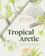
An illustrated visit to the tropical arctic of 205 million years ago when Greenland was green.

While today’s Greenland is largely covered in ice, in the time of the dinosaurs the area was a lushly forested, tropical zone. Tropical Arctic tracks a ten-million-year window of Earth’s history when global temperatures soared and the vegetation of the world responded.

A project over eighteen years in the making, Tropical Arctic is the result of a unique collaboration between two paleobotanists, Jennifer C. McElwain and Ian J. Glasspool, and award-winning scientific illustrator Marlene Hill Donnelly. They began with a simple question: “What was the color of a fossilized leaf?” Tropical Arctic answers that question and more, allowing readers to experience Triassic Greenland through three reconstructed landscapes and an expertly researched catalog of extinct plants. A stunning compilation of paint and pencil art, photos, maps, and engineered fossil models, Tropical Arctic blends art and science to bring a lost world to life. Readers will also enjoy a front-row seat to the scientific adventures of life in the field, with engaging anecdotes about analyzing fossils and learning to ward off polar bear attacks.

Tropical Arctic explains our planet’s story of environmental upheaval, mass extinction, and resilience. By looking at Earth’s past, we see a glimpse of the future of our warming planet—and learn an important lesson for our time of climate change.

Product Details

ISBN-13: 9780226534435
Publisher: University of Chicago Press
Publication date: 11/05/2021
Edition description: First Edition
Pages: 152
Sales rank: 1,094,278
Product dimensions: 8.20(w) x 10.20(h) x 0.80(d)

About the Author

Jennifer C. McElwain is the 1711 Chair of Botany at Trinity College Dublin, where she is also director of Trinity College Botanic Garden. She is the author of many publications, including The Evolution of Plants.


 Marlene Hill Donnelly is a scientific illustrator for the Field Museum in Chicago. She has illustrated three children’s books, including Big Tracks, Little Tracks.


Ian J. Glasspool is a research scientist and paleobotanist living in Maine. He has authored or coauthored fifty scientific articles.

Read an Excerpt

A small herd of musk oxen gallops below as we fly in a helicopter over the vast, stunted tundra landscape. The tundra is a unique ice-adapted vegetation and is considered one of the most threatened by current climate change. It will be thawed out of existence by rising temperatures if global climate warming remains unchecked. Dry hummocks—groups of tiny mounds— and sodden wet hollows— small holes— stretch below as far as our eyes can see. The plants that make up this treeless vegetation are low in species diversity, but vary in character and composition between the wetter and drier areas, resulting in a great floristic mosaic. Shades of brown, orange, and dull green sweep to the horizon. Billowing white flashes mark patches of bog cotton and remnants of snow unlikely to melt even in the high summer of the Arctic. All tundra vegetation today is low, growing in soils that are permanently frozen except for the topmost active layer. There are no trees in the modern Arctic landscape— it is too cold— but woody plants abound, including dwarf willow and birch, growing flattened to avoid wind chill. Another feature of the east coast of Greenland that we are skirting is the high proportion of bare land, where soils have yet to become established and vegetation cover is poor or absent. In these most recently deglaciated environments, only mosses and lichens survive. In winter, snow cover obscures these patches, and the active soil layers refreeze; in summer, however, they lie exposed, demonstrating the harshness of these high polar landscapes despite seasonal thaw.

In July 2002, more than 70 years after British paleobotanist Tom Harris’s pathfinding expeditions to the region, we were part of a National Geographic-funded expedition to discover and collect new plant fossils lying untouched, for hundreds of millions of years, in ancient sediments below East Green-land’s frozen tundra. We were a small group of researchers from Chicago, Copenhagen, Oxford, and Bucharest, almost complete strangers to one another, who had rendezvoused in Reykjavik with the ambitious plan of reconstructing Greenland’s lost floras as they transitioned through the third greatest mass extinction event in history at the close of the Triassic period, about 200 million years ago.

A prop-plane flight from Reykjavik brought us into our Jameson Land expedition base, Nerlerit Inaat. The Nerlerit Inaat airport is one of the most beautiful and remote air bases in the world. There are no roads linking it to human populations in the surrounding Sermersooq area (whose name translates from the Inuit as “place of much ice”). The only road, a runway, leads into Earth’s deep past, as it is flanked to the west by high cliffs that span the boundary of the Triassic (252-201 million years ago) and Jurassic (201-145 million years ago) periods.

From Nerlerit Inaat, the helicopter took off with our party of five, along with four weeks of food, camping, and collecting supplies. Our expedition had truly started. We were headed to our first field site, Ranunkeldal, on the Jameson Land peninsula, one of our northernmost sites. Finn Surlyk, from the Geological Survey of Denmark and Greenland, navigated for the pilot by counting the streams cutting through the Late Triassic-  and Jurassic-aged cliffs as we traveled north. We followed the invisible contours of the once formidable Kap Stewart Lake that occupied the Jameson Land peninsula during this interval and beyond. To the untrained eye, the ancient lake margins are invisible, but they have been extensively mapped through repeated studies of the rock sediments by Finn and his colleagues. This fundamental knowledge allowed us to interpret the paleo-landscape, now a ghostly relic in the great cliffs and remarkable outcrops of the Jameson Land region.

Our aim as a group of geologists and paleobotanists on this first expedition was to build a detailed scientific visualization of what the East Greenland landscape looked like in the Triassic and Jurassic. We were particularly interested in studying 208-201 million-year-old Rhaetian Age and 201- 199 million-year-old Hettangian Age sediments from the very latest Triassic and the very earliest Jurassic, respectively. These rocks and sediments contained the biological record of one of Earth’s “big five” mass extinction events, a biological crisis thought to have been triggered by a global warming of 6°C (10.8°F) or more. We wanted to understand what species and vegetation occupied the shores of Kap Stewart Lake before, during, and after the Triassic-Jurassic mass extinction event. What was the prevailing climate at this time and could we draw any parallels between the events of the past and our current biodiversity and climate emergencies? Our plan was to extract this information from fossil plants preserved in the sediments and rocks making up the jutting cliffs that now stood as our helicopter’s navigational guide northward to our first field site.

We chose a flat plateau site to land the helicopter and set up camp, due south of Ranunkeldal, which translates from the Danish to “Buttercup Valley.” Finn recommended the elevated site because valley camping in the Arctic is too cold. Sea mist rolls in just after midday and the rock cliffs prevent the daytime sun from penetrating the valley depths. Camp at 445 meters elevation consisted of a bedroom tent for each expedition member and one old-school canvas kitchen tent that we used for indoor cooking, dining, wrapping, and identifying fossil plants as well as writing up the day’s field notes. Each member of our group had defined roles— both scientific and more mundane day-to-day camp duties. We soon found that we represented a mix of experience, from completely uninitiated camper to seasoned fieldworker.

Nothing is quite like waking up in the red early morning glow of your first expedition morning in Greenland. The warmth of the sun heats your tent, and a gush of bracing pristine, crisp air rushes in as you unzip the door. The landscape appears utterly desolate when viewed at a macro scale, but soon begins to reveal its dwarf splendor and diversity as you investigate in more detail...

Our camp quickly took on a typical daily morning rhythm before we headed out on fieldwork each day. We brewed strong coffee on the stove each morning, made hearty soup for lunch, and reconstituted milk for cereal from stream water and dried powder. Jenny especially enjoyed wedges of Parmesan cheese and cured sausage with crackerbread...

On our first field day, we located the boundary between our target rocks, the Kap Stewart Group, and marine sediments of the Neill Klinter Group, which rest on top. These sediments were laid down at a time when Earth’s poles were completely free of ice. All the continents as we know them today were grouped into a supercontinent called Pangea. The climate of Greenland was as hot and sticky as that of the Florida Keys, and the oceans around it were warm, teeming with dinner plate-sized oysters...

Table of Contents

List of Illustrations

Preface

1 A Journey into the Past

2 Forests of a Lost Landscape

3 Crisis and Collapse

4 Recovery of a Tropical Arctic

Acknowledgments

Appendix: A Fossil Plant Gallery
Further Reading
Index
From the B&N Reads Blog

Customer Reviews