


Yellowstone Treasures: The Traveler's Companion to the National Park
400


Yellowstone Treasures: The Traveler's Companion to the National Park
400Paperback(Sixth edition)
-
PICK UP IN STORECheck Availability at Nearby Stores
Available within 2 business hours
Related collections and offers
Overview
This book makes you the tour guide for your group! Janet Chapple shares plenty of history anecdotes, with tips for you to spot wildlife, catch geyser eruptions, stay safe, and escape the crowds. Mile-by-mile road logs and maps show you everything there is to see. Updated by editor Beth Chapple, this sixth edition includes which geysers and hot springs are active, a new geological time line, new and enlarged color photos—adding up to more than 230 photos and illustrations—and 38 new and revised maps. Previous editions won Silver in the IBPA Benjamin Franklin Awards in 2010 and 2018.

Product Details
| ISBN-13: | 9781733103206 |
|---|---|
| Publisher: | Granite Peak Publications |
| Publication date: | 05/15/2020 |
| Edition description: | Sixth edition |
| Pages: | 400 |
| Sales rank: | 300,716 |
| Product dimensions: | 5.50(w) x 8.40(h) x 0.90(d) |
About the Author
Read an Excerpt
Yellowstone Treasures
The Traveler's Companion to the National Park
By Janet Chapple
Granite Peak Publications
Copyright © 2013 Janet ChappleAll rights reserved.
ISBN: 978-0-9858182-1-0
CHAPTER 1
NORTHWESTERN SECTION
Each road log section begins at a gateway community and continues into the park to a junction on the Grand Loop Road. The exception is section II, "The Bechler Region," whose roads do not connect with interior park roads.
Approaches to the West Entrance
From Bozeman, Montana, driving south on U.S. Highway 191 through the Gallatin Canyon, you traverse pleasant mountain scenery without crossing any high mountain passes. On this route, you can find all types of accommodations. About halfway along the 90-plus miles (145 km) from Bozeman to West Yellowstone is the road to the famous ski resort of Big Sky. Further south, more than 20 miles (32 km) of U.S. 191 pass inside the western edge of Yellowstone.
If you're approaching from the west or south, there are two other good roads you might take. They are U.S. 287 and the road from Pocatello, Idaho Falls, and Ashton, Idaho (Interstate 15, then U.S. 20). The Ashton to West Yellowstone drive is described in the other direction on pages 113–15.
Bozeman, Montana Bozeman Yellowstone International Airport
Population (2010): 37,300 8 mi. (13 km) NW
Bozeman is a rapidly growing town and one of Montana's oldest, established in 1864. The former agricultural college, now Montana State University, is the home of the Museum of the Rockies, with a planetarium and excellent dinosaur and geology exhibits.
FROM BOZEMAN TO THE WEST ENTRANCE
You'll need about two hours' driving time to cover the distance to West Yellowstone. The road follows the Gallatin River up its beautiful mountain-bound canyon. Take Interstate 90 west to Montana Highway 85, which leads to U.S. 191, or take U.S. 191 due west out out of town and then follow it south.
The village of Gallatin Gateway is 15 miles (24 km) from Bozeman, just off the highway. As you pass near it, you'll see the restored Gallatin Gateway Inn, built as the terminus of the Chicago, Milwaukee, St. Paul, and Pacific Railroad (nicknamed the Milwaukee Road), which operated a branch line to this inn from 1927 to 1961. In those years, park visitors arriving by train were met at the inn by the classic yellow park concessionaire's buses.
Soon you'll be following the canyon of the Gallatin River, flowing north out of the park and long famous for its trout. Fishing scenes in the movie A River Runs Through It were filmed here in the 1990s. Guest ranches and private vacation cabins are numerous in the canyon.
There are several Gallatin National Forest campgrounds and trailheads along the highway. Forty-three miles (69 km) from Bozeman is the turnoff to Big Sky. Motels and eating establishments are plentiful, and you'll find a small chapel near the turnoff. Since TV journalist Chet Huntley began it in the early 1970s, Big Sky has become a major vacation resort and skiing center. Before that, this part of the Gallatin Valley was fertile farmland; it was known for its lettuce and provided oats and hay for Yellowstone Park horses in the very early years.
Above Big Sky stands the pyramid of Lone Mountain, a glacial horn carved by the action of glaciers.
About 12 miles (20 km) south of the Big Sky Junction you begin to see eroded gray and yellow rock formations made of welded tephra, that is, particles erupted from a volcano. This tephra also tops Crown and Lava Buttes just inside the park.
As Black Butte appears in the distance, you pass a big turnout on the road's west side and then a lovely small cascade that enters the Gallatin River. Just beyond the cascade, look to the east side of the road (1.1 mile north of the Y.N.P. entrance sign), and you'll see Gorilla Rock, a jutting rock formation resembling a gorilla.
Along U.S. 191 in the Park
Approximately 60 miles (96 km) from Bozeman, Highway 191 enters the northwestern corner of Yellowstone, elevation about 6,700 ft (2,040 m), and continues inside the park for about 20 miles (32 km), crossing in and out of Wyoming and Montana. There are no campgrounds, picnic areas, or restrooms along this stretch of road, but there is access to several trails into the backcountry, both in the park and in Gallatin National Forest. This road was first built in 1910–11 and now passes through land that was added to the park in 1929.
Road Log
0.0/20.5 Yellowstone National Park boundary. Just a large sign marks the edge of the park here; there's no entrance fee to pay until you reach the West Entrance station.
This short stretch of U.S. 191 is the only road within the park where the speed limit is 55 miles per hour rather than 45. The only park road used by large trucks, it's open year round.
The mountains northeast of the road (to your left as you enter the park) are Crown Butte (elevation 8,051 ft / 2,454 m) and Lava Butte (7,904 ft / 2,409 m). Crown Butte resembles a crown when seen from the south. Geologists tell us that both Crown Butte and Lava Butte (a mile or two farther along) are topped with Huckleberry Ridge tuff, the 2-million-year-old welded tephra that can be seen in several localities in the park. Here the tuff overlies shale, a sedimentary rock rich in clays. Shale weathers and erodes easily, producing landslides that sometimes encroach upon the road.
0.9/19.6 [??] Dailey Creek Trailhead. Small parking area and Dailey Creek crossing. Dailey Creek was named for one of the first families to winter in the valley on the other side of the Gallatin Range. The family arrived in 1866 and still had a ranch there in the 1930s.
Lodgepole Creek joins the Gallatin opposite Dailey Creek. Note that locals pronounce the word creek like CRICK, to rhyme with trick.
All trails in this part of the park are long, steep ones that lead into the Gallatin Range. Dailey, Black Butte, and Specimen Creek trails all join with the Sky Rim Trail 5 miles or more away and 3,000 feet up (about 8 km away and 900 m up). The Sky Rim Trail affords spectacular mountain views to the very hardy climber or horseback rider. Also, some stumps of petrified wood are preserved there, but they are harder to reach and less interesting than those on Specimen Ridge in the Lamar River Valley. Both grizzlies and black bears live in this northwest corner of Yellowstone.
Along the far side of the river, you'll see red-tipped white stakes marking the park boundary.
2.6/17.9 [??] Black Butte Creek Trailhead; parking area on the west, trail on the east. This is the shortest but steepest of the trails that connect to the Sky Rim Trail.
3.0/17.5 The almost perfect cone shape of Black Butte looms over the road to the east. Unlike most buttes, this is not a flat-topped mountain. Geologists call Black Butte an igneous intrusion. This means that it's made of rock that rose as a molten mass from deep within the earth, but stopped and crystallized before reaching the earth's surface. Since the overlying rocks eroded away, we can now see the intrusion. Black Butte's rock is about 50 million years old.
3.9/16.6 There's a tiny stream called Wickiup Creek here. A wickiup was a temporary shelter used by nomadic tribes of Native American Indians. A group of these hunting lodges stood near the stream here in the park's early days.
4.6/15.9 [??] Specimen Creek Trailhead. This trail connects to the Sky Rim, High Lake, and Sportsman Lake trails. In spite of its name, this is not the best route to take to see petrified wood specimens. A ranger or local resident can best advise you on how to reach them. Remember that no samples may be removed from the park. Two easier ways to see petrified trees are by hiking from Yellowstone's northern approach road north of Gardiner, Montana, and at Petrified Tree near Tower-Roosevelt Junction.
To the east is Lightning Hill, so named when rangers from the now-razed ranger station near Wickiup Creek used to climb it to check for lightning-caused fires.
5.3/15.2 Road crosses the 45th parallel of latitude.
5.8/14.7 To the west, Snowslide Creek cascades into the Gallatin River in an area that's marshy except when the creek dries up in late summer. On the far side of the river along here, you can see remnants of the original road through Gallatin Canyon.
6.4/14.1 Terminal Monument Creek crossing. The strange name of this creek stems from a wooden post placed up the hill to the northeast that marks the northwest corner of the state of Wyoming.
7.5/13.0 Gallatin River Bridge.
8.8/11.7 [??] Bacon Rind Creek Trail begins 0.3 mile (0.5 km) up the side road to the west. After the first 2.5 miles (4 km), the trail continues out of the park into the Lee Metcalf Wilderness. The century-old name Bacon Rind Creek may have reflected breakfast around the campfire or baiting bears by hanging bacon rind in a tree.
As you travel south, you begin to see the snags, standing burned trees left from the Fan fire of 1988.
9.1/11.4 [??] Fan Creek and Fawn Pass Trailheads. Fan Creek flows into the Gallatin from the northeast through a valley that nineteenth-century geologists thought looked like a large fan, because of its radiating minor valleys. Both trails take hikers and riders into the southern expanses of the Gallatin Range.
[??] To see an undisturbed, beautiful mountain valley, you might follow the start of the Fan Creek Trail for about 2 miles (3 km), turning northeast at the trail junction.
10.5/10.0 From this point south, we no longer follow the Gallatin River. The river flows west from its source, then turns north here and meanders through the flat floodplain that you've just traversed if traveling southward. This is also the Montana/Wyoming state line.
10.9/9.6 [??] Bighorn Pass Trailhead. The sign indicates a short side road primarily for unloading horse trailers. The Bighorn Pass Trail follows the Gallatin River almost to its source at Gallatin Lake some 12 miles (19 km) away and 2,000 feet (610 m) up. Both the Bighorn Pass and Fawn Pass trails continue across the high mountains and all the way to the Grand Loop Road between Mammoth and Norris. Looking east up the Gallatin River here, you see Bannock Peak (10,332 ft / 3,149 m), with Quadrant Mountain (10,213 ft / 3,113 m) behind it.
In the 1920s, citizens and Milwaukee Road officials were eyeing the Bighorn Pass Trail route as an attractive place to build a road or a railroad. We must thank the first director of the National Park Service (NPS), Stephen Mather, and Yellowstone Park Superintendent Horace Albright for their foresight in objecting to these plans. Long before designated wilderness areas were thought of, Mather wrote to Albright: "We must keep a large area of Yellowstone in a state of untouched wildness if we are to be faithful to our trust as protectors of the wild life with which the park abounds." The road was not built, nor was the railroad company even allowed to conduct a survey.
12.0/8.5 Divide Lake, at an elevation of about 7,250 feet (2,210 m), takes its name from the fact that water flows from this vicinity into two different watersheds. To the north all streams flow to the Gallatin River, while to the south they flow to the Madison River. These rivers (along with the Jefferson River) join to form the Missouri River, and their waters eventually flow to the Atlantic Ocean.
14.0/6.5 Pass Creek and [??] Grayling Creek join here. U.S. 191 parallels Grayling Creek until that creek's southern exit from the park, crossing it three or four times. The old road crossed the creek even more times, to avoid having to excavate the sidehills.
The road skirts a severely burned area at the northwestern reach of the 1988 North Fork fire.
20.3/0.2 Tepee Creek crossing.
20.5/0.0 Yellowstone National Park boundary. Here U.S. 191 leaves the park.
From Outside the Park Boundary to West Yellowstone
From here U.S. 191 descends into the valley of the Madison River and reaches the town of West Yellowstone and the West Entrance in about 11 miles (18 km). Off to the west and southwest, you may see parts of the Snowcrest, Centennial, and Henry's Lake Ranges beyond Hebgen Lake. To the east is the high but relatively flat and tree-covered Yellowstone Plateau.
[??] At 1.4 miles (2.3 km) outside the park boundary and about 9.5 miles (15 km) north of West Yellowstone is the parking area for the Gneiss Creek Trailhead, next to the private Fir Ridge Cemetery road. This long trail is described from the other end at mile 7.6/6.3 on the West Entrance Road.
At the nearby junction with U.S. 287, you can take a side trip of less than 20 miles (32 km) to visit Hebgen Lake and Quake Lake, where you can see a remarkable landslide and learn about the devastating earthquake of 1959. In 8 miles (13 km) more on U.S. 191, you pass entrances to two Forest Service campgrounds and a private one, Yellowstone Airport, and a ranger station before entering West Yellowstone.
Quake Lake
If you're entering or leaving the park via the West Entrance, it's worthwhile to allow time for a visit to Earthquake Lake (often shortened to Quake Lake), northwest of West Yellowstone on U.S. 287. This is the site of the devastating August 17, 1959, earthquake and huge landslide that killed 28 people, most of them campers in a now-buried campground.
The landslide, caused by an earthquake of Richter magnitude 7.3, dammed the Madison River, forming the lake. This earthquake affected Yellowstone's Upper and Lower Geyser Basins more than 35 miles away.
Start your visit at the Forest Service visitor center, where you'll find exhibits and information about the earthquake and how a potential Madison River flood was avoided. Hebgen Dam, completed in 1915, cracked but did not give way in the quake.
West Yellowstone, Montana Yellowstone Airport
Population: 1,270 1.2 mi. (1.8 km) N
Motel and hotel accommodations and other tourist facilities are available throughout the year in the town of West Yellowstone. It's possible to travel by public bus between West Yellowstone and Bozeman, the only regularly scheduled public bus connection between one of the gateway communities and a larger city.
In winter, you can arrange snowcoach transportation from West Yellowstone to Old Faithful Village through the park concessionaire and several other companies. A snowcoach can carry 10 to 12 people in relative comfort over unplowed roads. In addition to serving as a starting point for snowcoaches, West Yellowstone is a major center for snowmobile rental.
West Yellowstone's first post office was established as Riverside in 1908, but the town soon changed its name to Yellowstone, Montana. This proved confusing, so in 1920 the name became West Yellowstone; locals now simply call it West.
Before 1908 the Union Pacific Railroad reached only to Idaho Falls, and visitors to the park traveled a day or more by stagecoach to reach the West Entrance. From that year until 1961, the U.P.'s Oregon Short Line served the town and this entrance to Yellowstone.
The former railroad station is now The Museum of the Yellowstone, featuring railroad history and exhibits about wildlife, the Hebgen Lake earthquake, and the 1988 fires. Another West Yellowstone attraction is the nonprofit Grizzly Discovery Center, currently home to nine grizzlies and eight gray wolves. These attractions are on or close to Yellowstone Avenue, the town's main street leading into the park, and both host park ranger programs in the summer. Also just outside the park entrance is the West Yellowstone Visitor Information Center.
[??] Riverside Trail (primarily a ski trail) enters the park from the eastern edge of town.
CHAPTER 2West Entrance to Madison Junction
From the West Entrance to Madison Junction
The West Entrance is the most popular way to enter Yellowstone, welcoming over 3,000 visitors each day in the summer months. In fact, it's second only to Grand Canyon National Park's South Rim as a busy national park entrance.
From West Yellowstone, this entrance road passes through stands of lodge-pole pine, burned in the devastating 1988 North Fork fire but now largely regrown. The Madison River is tepid all winter from geothermal runoff, which prevents ice from forming and provides habitat for the rare and beautiful trumpeter swan, which you may see here, especially in winter. There's also a strong possibility of seeing elk or bison.
The route you follow by taking this entrance road approximates that used by early-day trappers, Native American Indians, and some would-be gold miners. No gold in minable quantities was ever discovered within what is now the park. Stagecoach lines used this route to bring visitors into the new national park from 1880 until 1917, when buses and cars replaced stagecoaches completely.
(Continues...)
Excerpted from Yellowstone Treasures by Janet Chapple. Copyright © 2013 Janet Chapple. Excerpted by permission of Granite Peak Publications.
All rights reserved. No part of this excerpt may be reproduced or reprinted without permission in writing from the publisher.
Excerpts are provided by Dial-A-Book Inc. solely for the personal use of visitors to this web site.
Table of Contents
Preface 10
Acknowledgments 12
Introduction 13
Key to the Park Roads 13
When Is the Best Time to Visit? 15
Key to Symbols 17
Best Sights of Yellowstone 19
The Approaches to Yellowstone 21
Key to the Approach Roads 22
Road Logs and Destinations
I Northwestern Section 25
Approaches to the West Entrance 25
From the West Entrance to Madison Junction 35
From Madison Junction to Old Faithful Village 43
Old Faithful Village 69
Upper Geyser Basin 76
From Old Faithful Village to West Thumb Junction 101
Cascade Corner 108
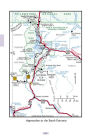
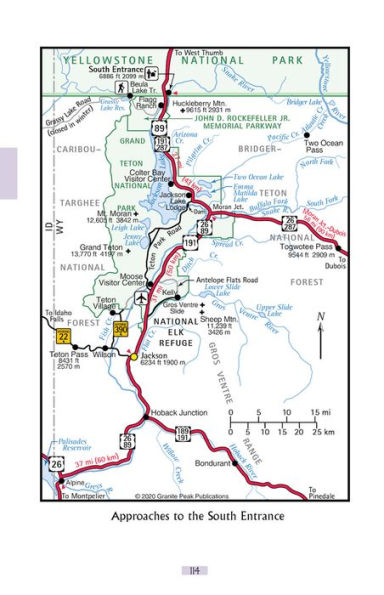
III Southern Section 113
Approaches to the South Entrance 113
From the South Entrance to West Thumb Junction 123
Facilities at Grant Village 128
From West Thumb Junction to Fishing Bridge Junction 132
West Thumb 132
Facilities at Lake Village 144
IV Eastern Section 149
From Cody to the East Entrance 149
From the East Entrance to Fishing Bridge Junction 157
Facilities at Fishing Bridge Village 164
From Fishing Bridge Junction to Canyon Junction 167
Facilities at Canyon Village 182
V Northeastern Section 185
Approaches to the Northeast Entrance 185
From the Northeast Entrance to Tower-Roosevelt Junction 195
From Tower junction to Canyon Junction 209
From Canyon Junction to Norris Junction 220
Norris Geyser Basin 224
VI Northern Section 238
From Livingston to the North Entrance 238
From the North Entrance to Mammoth Hot Springs Junction 245
Facilities at Mammoth Village 251
From Mammoth Junction to Norris Junction 263
From Norris Junction to Madison Junction 280
From Mammoth Junction to Tower Junction 287
Natural and Human History
Geological History 297
Chronology: Yellowstone Since 1800 319
Living Things: A Yellowstone Sampler 330
TRAVEL TIPS 356
A to Z Information 356
Useful Contacts 361
Yellowstone Books and Maps 363
Facilities in Yellowstone 367
Campgrounds In Yellowstone 368
54 Recommended Short Walks 369
Glossary 372
Index 376
Driving Distances 398
Maps
Yellowstone National Park 2-3
Key to the Park Roads 13
Key to the Approach Roads 22
Approaches to the West Entrance 26
West Entrance to Madison Junction 34
Madison Junction to Old Faithful Village 42
Fountain Paint Pot Loop 51
Old Faithful Village 70
Upper Geyser Basin 79
Old Faithful Village to West Thumb Junction 100
Cascade Corner and Environs 109
Approaches to the South Entrance 114
South Entrance to West Thumb Junction 122
Approximate Locations of Yellow-stone Plateaus 125
Grant Village 129
The Nine Large 1988 Fires in and near the Park 131
West Thumb Junction to Fishing Bridge Junction 133
West Thumb Geyser Basin 135
Lake Village 144
Eastern Section 150
East Entrance to Fishing Bridge Junction 156
Fishing Bridge Junction to Canyon Junction 166
Canyon Area: Village and Falls 174
Northeastern Section 184
Northeast Entrance to Tower-Roosevelt Junction 196
Tower-Roosevelt Junction to Canyon Junction 210
Canyon Junction to Norris Junction 221
Norris Geyser Basin 225
Approach to the North Entrance 239
North Entrance to Swan Lake Flat 244
Mammoth Village 252
Mammoth Hot Springs Terraces 259
Swan Lake Flat to Norris Junction 271
Norris Junction to Madison Junction 281
Mammoth Hot Springs Junction to Tower-Roosevelt Junction 286
Geological Points of Interest in and near Yellowstone 296
Geological Setting of Yellowstone Park 300
Three Yellowstone Ecosystems 333
Geological Figures
1 Cross section of the edge of the Yellowstone Caldera 41
2 How does a geyser work? 85
3 The Continental Divide 105
4 Cross sections showing the formation of the Teton Range 119
5 Plate tectonics and the Yellowstone hot spot 302
6 Cross sections showing evolution of the Yellowstone Caldera event cycle 306
What People are Saying About This
"Love for, knowledge of, and deep appreciation for this place... readable, informative, and user-friendly."
—author, The Spirit of Yellowstone
"This 'result of five years of research and preparation' has earned a permanent place on the Yellowstone bookshelf."
—webmaster, Yellowstone Notebook
"Chapple's lively narrative is as perfect for touring as it is for entertaining armchair reading."
—editor, Yellowstone and the Great West
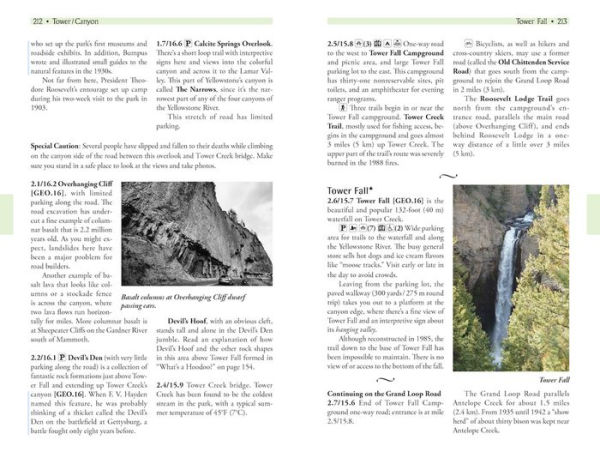
Related Subjects
Customer Reviews
Explore More Items


")


